Nowhere in the world is the interaction between people and water – both cooperation and opposition – as visible in the landscape as in the Belgian-Dutch Scheldt Delta. Spread over five provinces in both Belgium and the Netherlands, the area covers 5,500 square kilometers, divided over no fewer than 63 municipalities with more than one and a half million inhabitants.
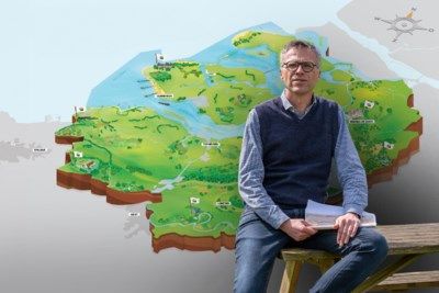
The Geopark Schelde Delta has been awarded a UNESCO quality mark for a number of weeks and runs from the coast through Antwerp to the Netherlands. — © GVA
When you think of the Scheldt, you think of Antwerp and mainly look at the area along the edges of the stream. But the Scheldt Delta Geopark is much more than that. The area extends from the Zwin nature reserve on the coast to the Boom clay pits across Antwerp towards the Netherlands.
READ ALSO. Walking through a drowned land and polders abandoned by man: “Lonely, but you are one with nature”
Professor Tim Soens, affiliated with the UAntwerp, explains what makes the area so unique and why it has received a UNESCO quality mark. “Unesco World Heritage is about buildings built by man, such as the cathedral in Antwerp. Geoparks are areas that are world heritage sites because of their unique soil and subsoil.”

Professor Tim Soens. — © Joris Herregods
There are many deltas in the world and some have long had the UNESCO quality mark. Major rivers in China and India or the area around the Mississippi in the United States, for example. And closer to home, the volcanic beaches of Lanzarote, and the lava fields and crater lakes of Iceland.
“In the delta we are not talking about a rock formation that is millions of years old and has hardly changed in all that time. This area is particularly dynamic. Constant erosion, demolition and construction, also due to human actions, have made the area what it is today. And we can be sure that that delta will change in the coming decades,” Tim Soens explains.
No conditions, no money
The current landscape of Geopark Schelde Delta is a story of 50 million years of subsidence and uplift, of sea level rise and fall, of tidal waters, rivers and climate change. In addition, it shows the alternating role of nature and human influences over the last two millennia.
“The reason why this geopark has received a quality mark is mainly due to the great value of the soil. This is of extraordinary value both ecologically and historically. The fact that humans have a major impact on the area and will continue to do so in the future is less important for obtaining the quality mark,” Tim Soens explains.
“The reason why this geopark has received a quality mark is mainly due to the great value of the soil. This is of extraordinary value both ecologically and historically”
Tim Soens
Professor UAntwerp
There are no conditions attached to the UNESCO quality mark, nor does it mean that budgets will be made available by the World Heritage Organization for the conservation and management of the delta. “The title draws attention to the value of the area and that is positive, because it is an additional argument for treating it with care.”
It has been ten years since the five provinces involved – Zeeland, North Brabant, Antwerp, East and West Flanders – jointly submitted an application file to UNESCO. With the quality mark in hand, these provinces and the municipalities in the area will further capitalize on the tourist assets of the area.
Water up to the knees or higher
Whether the Geopark Schelde Delta will suddenly become a huge crowd puller by obtaining the quality mark is unlikely and not the intention. “There is already a lot of tourism in the area, although people who go walking or cycling may not realize that they are in the park,” says Tim Soens.
The professor mainly sees new opportunities for education. “The area is a huge gift for geography and history teachers. Actually, they can visit the area anywhere between Bruges and Antwerp. The learning material is, so to speak, just around the corner for the taking.”
“Unesco World Heritage is about buildings built by man, such as the cathedral in Antwerp. Geoparks concern areas that are world heritage because of their unique soil and subsoil.”
Tim Soens
Professor UAntwerp
Tim Soens himself wants to start a campaign to restore a number of flood marks in the area. “Flood marks are actually nothing more than arrows and lines that used to be applied to buildings and indicate how high the water used to be at that location. There are a few more such brands in the Netherlands. Not in Flanders as far as I know.”
The flood marks would give a good picture of how water determined life in the Scheldt Delta in the past. “There are places where the water used to be at knee height or higher. This way you learn that humans have not only lived for centuries with the movement of water. It also explains why people often sought higher areas or at times moved elsewhere.”

The value of the area lies mainly in the subsurface. The clay and sand layers contain tens of thousands of years of history. — © Geopark Scheldt Delta
In the Scheldt Delta it is clearly visible which higher areas were popular for residential purposes. “The entire ring of old cities such as Bruges, Antwerp and Bergen op Zoom across the Dutch border are good examples of this. It is not without reason that cities were created exactly there,” explains Tim Soens.
“At the Vleeshuis in Antwerp you can still clearly see that the remainder of the old city center is quite high. It is a difference of about five meters to build higher than the water”
Tim Soens
Professor UAntwerp
These are all cities located on the edge of the coastal plain. “Or better from what was then the coastal plain. It sounds strange to modern people, but Antwerp is actually a coastal city. At the Vleeshuis in Antwerp you can still clearly see that the remainder of the old city center is located quite high. It’s a difference of about five meters.”
Development of port no objection
In a valuable area, which is also honored by UNESCO, a heavily industrialized area is not the first thing that comes to people’s minds. Yet the port of Antwerp is dominant and in the middle of the Scheldt Delta Geopark. But that is no reason for concern for Tim Soens.
“A UNESCO geopark is in no way intended to stop the development of the port or other industrial areas. The quality mark primarily concerns the subsoil of the area. In that respect, the expansion of the port has provided us with a number of benefits.”
Including when digging docks. “The most recent is the construction of the Waaslandhaven. This type of work gives archaeologists the opportunity to make cross-sections of the soil layers very deep into the ground. It gives an image of that area over the past ten thousand years and sometimes even longer ago,” the professor continues.

The port of Antwerp has a dominant presence in the area. But that does not detract from the uniqueness of the Scheldt Delta. — © ANP/Peter Hilz
Tim Soens points out that man’s influence on the Scheldt Delta is not something that occurred in the past hundreds of years. “The Romans already did it and over the centuries man has adapted and shaped the landscape several times by building cities and dikes. That is normal practice.”
Dutch people are aware of the impact of water
Tim Soens’ message is clear: use the Scheldt Delta, but also let nature take its course. “I call this co-evolution in which people, water and land jointly determine the landscape. People often talk about man’s struggle against water. I don’t follow that. It is not a battle against the water, but living with the water.”
According to the professor, the Dutch are more aware of this than the Flemish. “That is of course because the Netherlands has a long history with water. For Flanders, this area is the edge of the country. For the Netherlands, the delta is part of the core of the country and a densely populated area.”
“In the Netherlands they often say that the risk of flooding does not come from the sea, but from the rivers. That realization is less common in Flanders.”
Tim Soens
Professor UAntwerp
The Dutch realize better than anyone that their country is largely below sea level and that makes the importance of good water management more important than ever. “In the Netherlands they often say that the risk of flooding does not come from the sea, but from the rivers. That realization is less common in Flanders.”
Floods are part of it
In the meantime, Flanders is busy arming itself against flooding and global warming. Including the Sigma Plan, which is intended to protect the Scheldt Valley in particular against flooding by raising dikes, constructing storm surge barriers and creating flood areas.
“The Sigma Plan is a good thing, but at the same time it is virtually impossible to protect inhabited areas against water into the distant future. In the Middle Ages, a period that I study, people also lived in the Scheldt Delta. There were hundreds of villages that sometimes flooded and were therefore moved to another place.”

Professor Tim Soens. — © Joris Herregods
This is not a plea to move villages and towns now to escape the water. Tim Soens does say that building higher and higher dikes is not necessarily the solution. “There is always a weak spot somewhere through which the water finds its way. Because a dike can collapse or because rabbits dig tunnels somewhere in that dike.”
Antwerp a bit under water
For Tim Soens it is clear that the dynamics present in the Geopark Schelde Delta must be preserved. “And at the same time you also have to ensure that our cities and villages are not flooded. Which means you have to build higher and better dikes. It seems to me to be a very difficult exercise to unite the two.”
According to the professor, the solution to this problem partly lies in the past. “I sometimes say, somewhat provocatively, that we have to build dikes to ensure that floods do not cost lives. But not more than that. Is it really a big problem that there is half a meter of water in the streets of Antwerp every thirty years? We are not obliged to store expensive items in the basement.”
Tags: Scheldt Delta Geopark receives UNESCO recognition Antwerp coastal city Antwerp
-


)